LandSerf 1.8 User's Guide
1. Introduction
LandSerf allows you to visualise and perform analysis on elevation models of
continuous surfaces. It currently supports raster DEM and vector TIN, contour
and metric surface network models of elevation. What makes the software unique,
is the ability to perform surface analysis over a range of scales, and characterise
any scale dependent behaviour.
1.1 Starting LandSerf
Depending on how you installed the software, LandSerf can either be started from the Start Menu (Windows),
a desktop icon (Windows, MacOS, Unix), or the command line (Windows, MacOS, Unix). By starting from the
command line, various command line parameters can also be provided that will start LandSerf with rasters
and/or vector files preloaded. The options are given below.
| Command line parameter | Explanation |
surface <raster_file> | Starts with the given LandSerf raster loaded as the processing surface |
drape <raster_file> | Starts with the given LandSerf raster loaded as the processing drape |
vector <vector_file> | Starts with the given LandSerf vector loaded |
base <start_directory> | The initial directory used for file loading/saving. |
display <raster|relief|vector> | Starts LandSerf with the given parameter displayed. |
hub <config_file> | Starts with the virtual field course Hub set to that in the given configuration file. |
| Examples: |
LandSerf.exe raster c:\data\mountains.srf display relief |
| | Start LandSerf (in Windows) with the file mountains.srf displayed as a shaded relief map. |
landserf vector ~/data/coast.vec display vector hub ~/vfc/hub.cfg |
| | Start LandSerf (in Unix) with the file coast.vec displayed and the VFC hub configured from the file hub.cfg. |
1.2 Using LandSerf
The system is largely controlled via a series of menus that either perform
actions or open further dialogue boxes. Graphics appear in the main (sunken)
window, while the status of the system is reported at the bottom of the window.
For processing that is likely to take some time, a 'percentage complete'
message is displayed in the bottom right-hand corner. The entire window can be
resized at any stage with all graphics being rescaled accordingly.
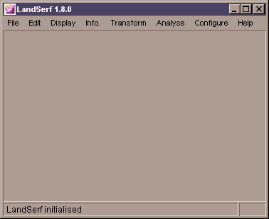 LandSerf's initial screen.
LandSerf can simultaneously store up to two raster models of elevation and one
vector model. The two raster models consist of a surface model and
drape model. Analysis is usually performed on only one of these models at a
time. To change between surface and drape models, select from the menu. The range of
visualisation and analysis options available will depend on which of these has
been selected.
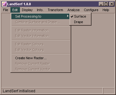 Changing from surface to drape processing.
1.3 Functionality
The following features are currently available in LandSerf 1.8.
- Raster and vector files stored using LandSerf's own (platform
independent) file format.
- Raster import from ArcGIS (ASCII and binary image) and GRASS (ASCII only); the visualisation
software VistaPro (ASCII and 16 bit binary), Virtual Terrain Project 'BT files' and
Terragen (8 bit binary); ASCII raster DEMs from Ordnance Survey (NTF 2.0) and EDX;
generic ASCII and 8/16/24/32 bit binary; Virtual Field Course rasters and images via
the internet, and GIF and JPEG graphics file formats.
- Vector import from ArcGIS (ASCII 'generate files'); the GIS GRASS (ASCII only); Virtual
Field Course Vectors; a generic ASCII point and vector format.
- Raster export for the ArcGIS and GRASS GIS (ASCII only); the visualisation
software VistaPro (ASCII and 16 bit binary formats) and Terragen (257x257 8 bit binary rasters);
VRML virtual worlds; a generic ASCII and 16 bit binary raster format, and a generic (x,y,z) point file ASCII format.
- Vector export for the ArcGIS (ASCII 'generate' files) and GRASS GIS (ASCII only); a generic
ASCII text format; 3d vector flythroughs over elevation models; and a generic surface network ASCII file format.
- LandSerf files can be printed directly. Output includes the current
raster image, its title, bounds and supplementary notes.
- Raster title and supplementary notes.
- Raster boundary positions and resolution including interactive subsetting and reinterpolation.
- Raster colour tables.
- Raster layer combination.
- Vector title, boundary positions and supplementary notes.
- Vector colour tables.
- Interpolated 'k-colour' raster.
- Shaded relief with variable blending with 'k-colour' rasters.
- Coloured vector overlay.
- Blended surface and drape images (average R, G and B values).
- Hue-Saturation images (surface representing saturation, drape
representing hue).
- Pseudo '3D' perspective views with interactive 'flythrough'
navigation (Windows only).
- Raster information - title, bounding area, min/max values,
colour table, raster type, supplementary notes.
- Vector information - title, bounding area, min/max values,
colour table, supplementary notes.
- Interactive query of raster values, reported as (x,y,z) triplets.
- Interactive query of changing surface parameters/features with
scale, reported as a parameter-scale graph.
- Scatterplot of surface and drape values.
- Frequency histogram of surface values.
- 'Hammock Plot' of surface values (detects interpolation artifacts).
- Vector to raster conversion.
- DEM to TIN and TIN to DEM conversion.
- Delaunay triangulation of points.
- Contour threading of DEMs.
- Raster value transformations (scaling, translation etc.)
- Calculation of elevation, slope, aspect, 7 measures of curvature,
and feature type at any scale.
- Average and variation of any surface parameter/feature over a
range of window scales.
- Surface feature network derivation (creates linear networks of
ridges and channels bounded by pits, passes and peaks).
- User defined selection of analysis scale and distance decay
parameters.
- User defined selection of feature extraction tolerances.
- Shaded relief parameter settings (sun elevation and azimuth,
reflectance properties etc.)
- Virtual Field Course Hub connection configuration (allows data to
be read/written over the internet).
You do not appear to have style sheets enabled on your browser. These pages will be much improved if you use a more recent
browser that supports cascading style sheets.
