

Calculates a surface of fractal dimension values in a window around each raster cell.
LandSerf can calculate the fractal dimension of a surface using the 'Variogram method' as suggested by Mark and Aronson (1984) and others. As with all global fractal dimension calculations, this measure can hide non-fractal behaviour and spatial variation in roughness. An alternative approach is to calculate fractal dimension within a window around each cell of a raster. The result is an entire raster map of fractal dimension values indicating how surface roughness changes over space. This addon allows you to calculate this 'focal' fractal dimension (so named after Tomlin's (1989) naming of focal operations that compare locations with their neighbours) and store the results in a raster map.
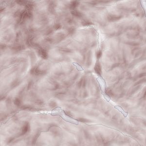
The image to the left shows an example of a raster produced by focalD. Fractal dimension varies between 2.0 (white) indicating smooth, scale invariant behaviour and a theoretical maximum of 3.0 (dark brown) indicating a space-filling rough surface. The example shown here is taken from a DEM of the English Lake District, (Crown Copyright Ordnance Survey) with major lake and stream network overlain for context. The large number of cells with a focal fractal dimension of around 2.0 are associated with flat lakes and smooth valley floors.
To install the FocalD calculator, download the appropriate file below and uncompress into your LandSerf installation folder
(e.g. c:\Program Files\landserf220). This should create a sub-folder called addons with several
files including FocalD.bat and FocalD.sh.
To run the FocalD calculator, open a command prompt in Windows (Start menu -> Run... -> cmd) or a shell/terminal
window in Lunux/MacOSX. Change to the directory in which the converter is installed (e.g. cd "Program files"\landserf220\addons)
and type FocalD surface.srf where surface.srf is the LandSerf raster you wish to measure. You can
optionally specify the size of the window to use which must be and odd number of at least 9x9 cells. If not specified, the window
size stored in the raster will be used (this is the same as the one used for calculating slope, curvature etc at different scales).
Output will be a file with the same name but with FocalD appended.
The following will create a new file called myRasterFocalD.srf in the same directory as myRaster.srf
containing fractal dimensions measured in the 25x25 cell window surrounding each cell.
FocalD c:\data\myRaster.srf 25 (Windows)
or
./FocalD.sh ~/data/myRaster.srf 25 (Linux/MacOSX)
Mark, D. M. and Aronson, P.B. (1984) Scale-Dependent fractal dimensions of topographic surfaces: An empirical investigation with applications in geomorphology and computer mapping, Mathematical Geology, 16 (7), pp.671-683.
Tomlin C.D. (1989) Geographic Information Systems and Cartographic Modelling.