| |
New Graphical User Interface
 LandSerf now uses a customised Graphical User Interface with keyboard shortcuts and a consistent look and feel.
Much of the common functionality can be accessed from a toolbar at the top of the screen. Thumbnail previews
of stored surface models are shown at all times.
LandSerf now uses a customised Graphical User Interface with keyboard shortcuts and a consistent look and feel.
Much of the common functionality can be accessed from a toolbar at the top of the screen. Thumbnail previews
of stored surface models are shown at all times.
An unlimited number of spatial models can now be stored and processed. 'Active' surface models can be selected
with the mouse. Many functions can be controlled graphically, such as the new colour editing facility with
preset colour tables.
|
|
New Functionality
 LandSerf 2 contains new functionality such as rectification of non-georeferenced images, allowing scanned
rasters and images to be georeferenced and combined with other spatial models. Rasters and vectors referenced
with global lat/long coordinates can be projected onto UTM or OS National Grid coordinate systems. Rasters can
now store 'null' values that do not get processed. This is useful for representing missing data and water/islands.
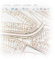
Improved vector handling can now handle areas, islands and 'holes' as well as import of GML and Shapefile format vector
maps.
LandSerf 2 contains new functionality such as rectification of non-georeferenced images, allowing scanned
rasters and images to be georeferenced and combined with other spatial models. Rasters and vectors referenced
with global lat/long coordinates can be projected onto UTM or OS National Grid coordinate systems. Rasters can
now store 'null' values that do not get processed. This is useful for representing missing data and water/islands.
Improved vector handling can now handle areas, islands and 'holes' as well as import of GML and Shapefile format vector
maps.
|
| |
Interaction
 All surface models can now be interactively 'zoomed' and 'panned'. This provides a convenient tool for the
exploration of scale dependencies in models. The 3d viewer has been significantly enhanced with the addition
of 'collision detection' (no more tunnelling though mountains), added user-defined surface detail and improved
navigation with the mouse.
All surface models can now be interactively 'zoomed' and 'panned'. This provides a convenient tool for the
exploration of scale dependencies in models. The 3d viewer has been significantly enhanced with the addition
of 'collision detection' (no more tunnelling though mountains), added user-defined surface detail and improved
navigation with the mouse.
Many of the surface query operations have increased dynamic interaction such as multi-scale parameter query,
histogram and shaded relief calculation.
|


 With a rewriting of the LandSerf code come significant performance and efficiency gains. Spatial files are now
compressed on loading and saving. The 3d viewer is faster and takes advantage of recent developments in OpenGL
and graphics accelerators. Vector handling is faster and rendering higher quality.
With a rewriting of the LandSerf code come significant performance and efficiency gains. Spatial files are now
compressed on loading and saving. The 3d viewer is faster and takes advantage of recent developments in OpenGL
and graphics accelerators. Vector handling is faster and rendering higher quality.